
| Model: | KC2800 |
|---|---|
| Brand: | AIBIRD |
| Origin: | Made In China |
| Category: | Toys / Remote Control Toys |
| Label: | UAV , drone , aircraft |
| Price: |
US $45000
/ set
|
| Min. Order: | 1 set |
| Live Chat: | Last Online:23 May, 2015 |
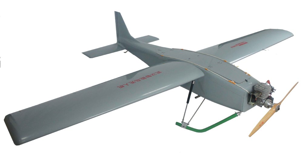
AIbirdUAV KC2800 Mapping drone
The professional mapping drone
Use this fully autonomous drone to capture high-resolution aerial photos that you can transform into accurate 2D orthrombosis & 3D models.
Four reasons to choose the KC2800
1. Map more, more accurately: The KC2800 can cover up to 30-50 sq. km in a single flight, and over smaller areas, flying at lower altitudes, it can acquire images with a Cannon 5DMarkII of down to 1.5 cm/pixel.
2. No flying skills required: The KC2800 is easy to launch with the auto launch system, It then flies, captures images & lands itself. (However you can reprogram its flight or land manually if required.)
3. Because safety matters: The KC2800 uses Fiber Reinforced Plastics material, stable structure, minimizing its impact energy.
4. It’s all you need: The KC2800 is supplied with two sturdy carry case and two software packages: KC1600 ground station (flight planning and control) & AIbird UAV 3D Mapping (professional photogrammetry)
Technical specifications
Hardware
Weight (inc. supplied camera): Approx. 19.0 kg
Wingspan: 2800 mm
Material: Fiber Reinforced Plastics
Propulsion: Gasoline Engine
Fuel load: 6.0L
Camera (supplied): Cannon 5DMarkII
Cameras (optional): S110 RGB, thermo MAP
Carry case dimensions: 300 x 250 x 250 mm
Operation
Maximum flight time: 2-3hours
Nominal cruise speed: 110 km/h
Radio link range: 20-60km
Maximum coverage (single flight): 30-50 km²
Wind resistance: Up to 45 km/h (12m/s or 28 mph)
Ground Sampling Distance (GSD): Down to 1.5 cm (0.6 in) per pixel
Relative orthomosaic/3D model accuracy: 1-3x GSD
Absolute horizontal/vertical accuracy (w/GCPs): Down to 3 cm (1.2 in) / 5 cm (2 in)
Absolute horizontal/vertical accuracy (no GCPs): 1-5 m (3.3-16.4 ft)
Multi-drone operation: Yes (inc. mid-air collision avoidance)
Automatic 3D flight planning: Yes
Linear landing accuracy: Approx. 5 m (16.4 ft)
The KC2800 Mapping system solution
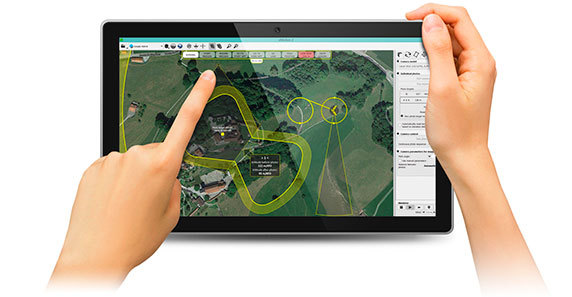
1. Plan your flight
AIbirdUAV ground station software makes it easy to plan and simulate your mapping mission.
Plan: Import your preferred base map and define the area you want to cover. Then specify your required ground resolution, with a maximum GSD of 1.5 cm, and image overlap.
Ground station automatically generates a full flight plan, calculating the KC2800 required altitude and displaying its projected trajectory.
Flying over uneven terrain? Use ground station’s 3D mission planning feature to take elevation data into account when setting the altitude of waypoints and the resulting flight lines – improving ground resolution and increasing safety.
Simulate: To ensure your mission’s success, run a virtual flight that simulates wind strength and direction. Then make any flight plan updates required and prepare to launch.
2. Fly
Launch: To launch the KC2800, auto to launch form launching cradle by auto system.
The artificial intelligence inside the KC2800 autopilot continuously analyses data provided by the Inertial Measurement Unit and onboard GPS to control every aspect of its flight.
Monitor: Using KC2800 ground station software you can view the KC2800 flight parameters, battery level and image acquisition progress in real time.
Control: Made a mistake with your planning? Reprogram your drone’s flight plan and landing point mid-flight.
3. Create
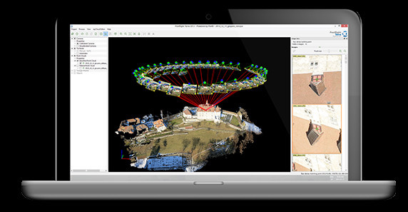
Process: Use the KC2800 supplied AIbirdUAV Mapping software to easily process your flight’s photos.
In just a few clicks you can transform this imagery into geo-referenced 2D orthomosaics, 3D point clouds, triangle models and Digital Elevation Models (DEMs).
Trust: With the KC2800 GSD of down to 1.5 cm, relative orthomosaic/3D model accuracy of 1-3x GSD, and absolute horizontal/vertical accuracy of down to 3/5 cm, you can have full confidence in the accuracy of the outputs you produce.
4. Your results
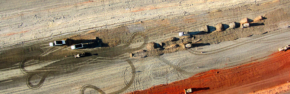
Once you have created your orthomosaic and 3D model, it's time to put this data to work - for example by measuring distances, taking cross-sections, extracting volume data, or exporting to third-party software to add GIS data or create custom maps.
| Payment Terms: | T/T |
|---|---|


